EN
°F
Change your measurements
Meters
Feet
°C
°F
km/h
mph
kts
am/pm
24-hour
Your settings have been updated
Change your language
Deutsch
Español
Italiano
Nederlands
中文
English
Français
日本語
Português
Today
7 days
Weather
Fishing
Water temp
United States
tide charts
Washington
tide charts
Pacific County
tide charts
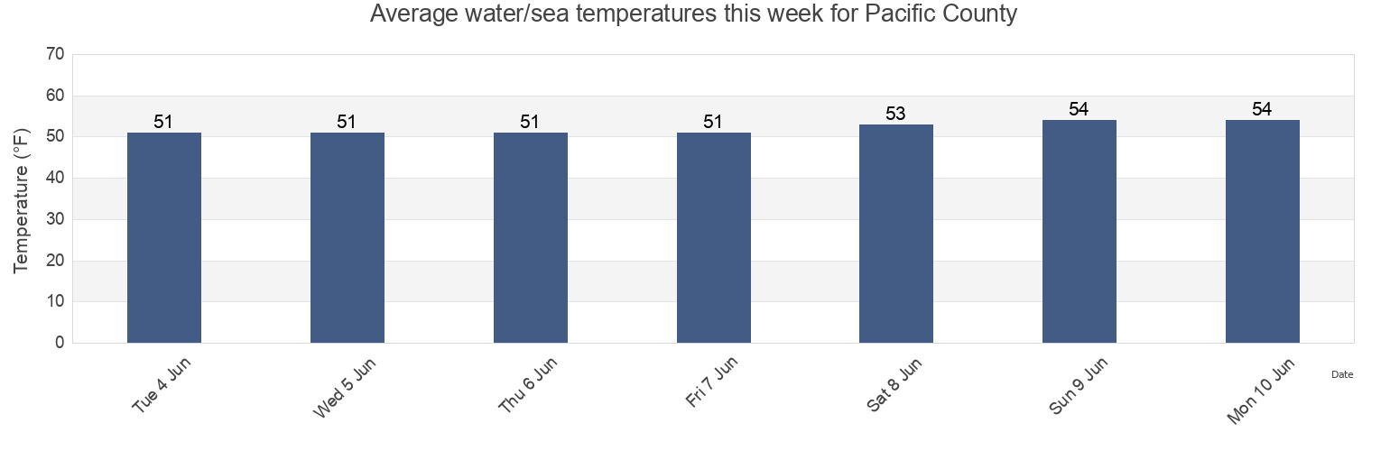
Pacific County water temperature
Pacific County water temperature for today, tomorrow and this week
More tide and marine information for Pacific County
Today's tides
Weekly tides
Weather
Fishing tides
Regions and cities in Pacific County, Washington, United States
Baker Bay entrance E of Sand Island Tower
Long Beach
Raymond Willapa River
Bay Center (Palix River)
Mailboat Slough (Willapa River)
Sand Island Tower 0.9nm SE of (north channel)
Bay Center Palix River
Mailboat Slough Willapa River
South Bend
Beards Hollow
Nahcotta
South Bend (Willapa River)
Cape Disappointment
Naselle (Naselle River)
South Bend Willapa River
Chinook Baker Bay Wash.
Naselle River 4 Miles Above Swing Bridge
South Fork (Palix River)
Show more locations
Columbia River Entrance (N. Jetty)
Naselle River Swing Bridge
Swing Bridge (Naselle River)
Fort Canby (Jetty A)
North Cove
Tarlatt Slough
Fort Canby A Jetty
Ocean Park
Toke Point
Fort Canby Jetty A Wash.
Palix River South Fork
Tokeland
Fort Canhy
Paradise Point (Long Island)
Willapa Bay
Hungry Harbor., Columbia River
Paradise Point Long Island
Willapa City, Willapa River
Ilwaco Baker Bay Wash.
Raymond
Leadbetter Point
Raymond (Willapa River)
Tide charts near Pacific County
Willapa City, Willapa River
South Fork (Palix River)
Palix River South Fork
South Bend Willapa River
South Bend
South Bend (Willapa River)
Raymond (Willapa River)
Raymond Willapa River
Raymond
Mailboat Slough Willapa River