Georgetown County tide charts for today, tomorrow and this week

Georgetown County, South Carolina, United States tide chart

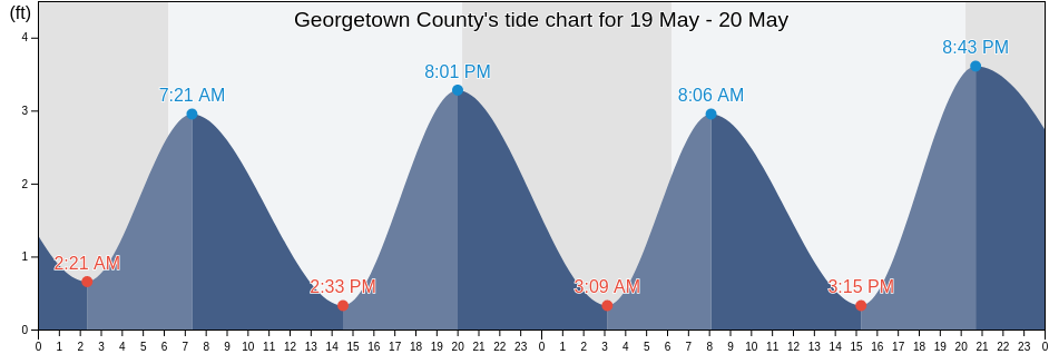
Saturday 27 April 2024, 8:11PM EDT (GMT -0400). The tide is currently rising in Georgetown County. As you can see on the tide chart, the highest tide of 3.61ft was at 12:18am and the lowest tide of 0.33ft was at 7:46am. Click here to see Georgetown County tide chart for the week.

Next high tide

Next high tide is at
1:00am

Next low tide

Next low tide is at
8:32am

Tide times for Georgetown County

Tide table for Georgetown County this week
Day Tide times for Georgetown County Sunrise and sunset
1st Tide 2nd Tide 3rd Tide 4th Tide
Sat 2712:18am
3.61 ft
7:46am
0.33 ft
12:27pm
2.95 ft
7:33pm
0.33 ft
6:32am 7:57pm
Sun 281:00am
3.61 ft
8:32am
0.33 ft
1:12pm
2.95 ft
8:19pm
0.33 ft
6:31am 7:58pm
Mon 291:50am
3.61 ft
9:22am
0.33 ft
2:06pm
2.95 ft
9:13pm
0.33 ft
6:30am 7:59pm
Tue 302:48am
3.61 ft
10:19am
0.33 ft
3:10pm
2.95 ft
10:18pm
0.33 ft
6:29am 8:00pm
Wed 13:51am
3.61 ft
11:19am
0.33 ft
4:19pm
2.95 ft
11:28pm
0.33 ft
6:28am 8:00pm
Thu 24:56am
3.61 ft
12:21pm
0.33 ft
5:27pm
3.28 ft
6:27am 8:01pm
Fri 312:40am
0.33 ft
6:00am
3.61 ft
1:19pm
0 ft
6:32pm
3.61 ft
6:26am 8:02pm

Best fishing times for Georgetown County today Today is an average fishing day

Major fishing times

Minor fishing times

Click here to see Georgetown County fishing times for the week.

Current weather in Georgetown County

Partly cloudy

Weather

Cloud cover 10%
Temperature

Temperature

66°F
Min 63°F/Max 72°F
Wind

Wind

9 mph
Wind gust 17 mph
Humidity

Humidity

71%
Dew point 56°F

Click here to see Georgetown County weather for the week.

Today's weather in Georgetown County

The sun rose at 6:32am and the sun went down at 7:57pm. Today there was 13 hours and 25 minutes of sun and the average temperature is 69°F. At the moment water temperature is 62°F and the average water temperature is 62°F.

Weather forecast for Georgetown County today
0 h 3 h 6 h 9 h 12 h 15 h 18 h 21 h 24 h
Partly cloudyPartly cloudyPartly cloudyPartly cloudyPatchy rain nearbyCloudyPartly cloudyPartly cloudyPartly cloudy
65°F71°F66°F71°F72°F71°F66°F66°F65°F

Click here to see Georgetown County weather for the week.

More tide and marine information for Georgetown County

Regions and cities in Georgetown County, South Carolina, United States

Allston CreekGarden City Pier (ocean)Oyster Landing (N. Inlet Estuary)
Arundel PlantationGeorgetownOyster Landing Crab Haul Creek North Inlet
Bennet's DockGeorgetown LighthousePawleys Island
Bennets Dock Pawleys Island CreekGeorgetown Sampit RiverPawleys Island Pier (ocean)
Black River (south Of Dunbar)Hagley LandingPee Dee River swing bridge
Brown Island (South Santee River)Holly Grove PlantationPleasant Hill Landing (Santee River)
Brown Island South Santee RiverJacobs WharfPleasant Hill Landing Santee River
BucksportLafayette swing bridge Waccamaw RiverRabbit Island northwest of
Bull Creek EntranceLitchfield BeachRange D off Mosquito Creek
Butler Island 0.3 mile south ofLitchfield Beach BridgeSampit River entrance
Cape RomainLittle Bull Creek Entrance (Bull Creek)Smith's Dock
Cape Romain (46 Miles East Of)Little Bull Creek Entrance Bull CreekSouth Island Ferry (Intracoastal Waterway)
Cape Romain 46 Miles East OfLower Topsaw LandingSouth Island Plantation
Captain Alex's MarinaMagnolia BeachSouth Of Sam Worth Game Management Area
Captain Alexs Marina Parsonage CreekMc Clellanville Jeremy CreekSouth Santee River (Highway 17 Bridge)
Carr Creek (1 mile above entrance)Mcclellanville (Jeremy Creek)South Santee River entrance
Carr Creek 1 Mile Above EntranceMcClellanville Jeremy CreekThe Pier (Pawleys Island)
Casino CreekMidway Inlet North (Pawleys Island)Thoroughfare Creek Entrance
Casino Creek ICWWMidway Inlet North Pawleys IslandU S Highway 17 Bridge South Santee River
Cedar Island (North Santee Bay)Minim Creek Entrance (North Santee Bay)U.S. Highway 17 Bridge South Santee River
Cedar Island North Santee BayMt Pleasant Plantation Black RiverWaccamaw River Entrance
Cedar Island Point (South Santee River)Mt. Pleasant Plantation (Black River)Wachesaw Landing
Cedar Island Point South Santee RiverMt. Pleasant Plantation Black RiverWard's Dock
Clambank Creek (North Inlet)Murrells InletWards Dock Pawleys Inlet
Clambank Creek Goat Island North InletNorth SanteeWeymouth Plantation
Divine's DockNorth Santee BridgeWindsor Plantation (Black River)
Frazier PointNorth Santee River entranceWindsor Plantation Black River
Frazier Point south ofNorth Santee River InletWinea Plantation (Black River)
Frazier Point west ofOaks Creek (0.5 Mi. Above Entrance)Winea Plantation Black River
Garden City Bridge (Main Creek)Oaks Creek (Upper End)Winyah Bay Entrance (south Jetty)
Garden City Bridge Main CreekOceanside BeachYauhannah Bridge

Popular locations in Georgetown County

Murrells InletPawleys Island Pier (ocean)