EN
°F
Change your measurements
Meters
Feet
°C
°F
km/h
mph
kts
am/pm
24-hour
Your settings have been updated
Change your language
Deutsch
Español
Italiano
Nederlands
中文
English
Français
日本語
Português
Today
7 days
Weather
Fishing
Water temp
United States
tide charts
Oregon
tide charts
Clatsop County
tide charts
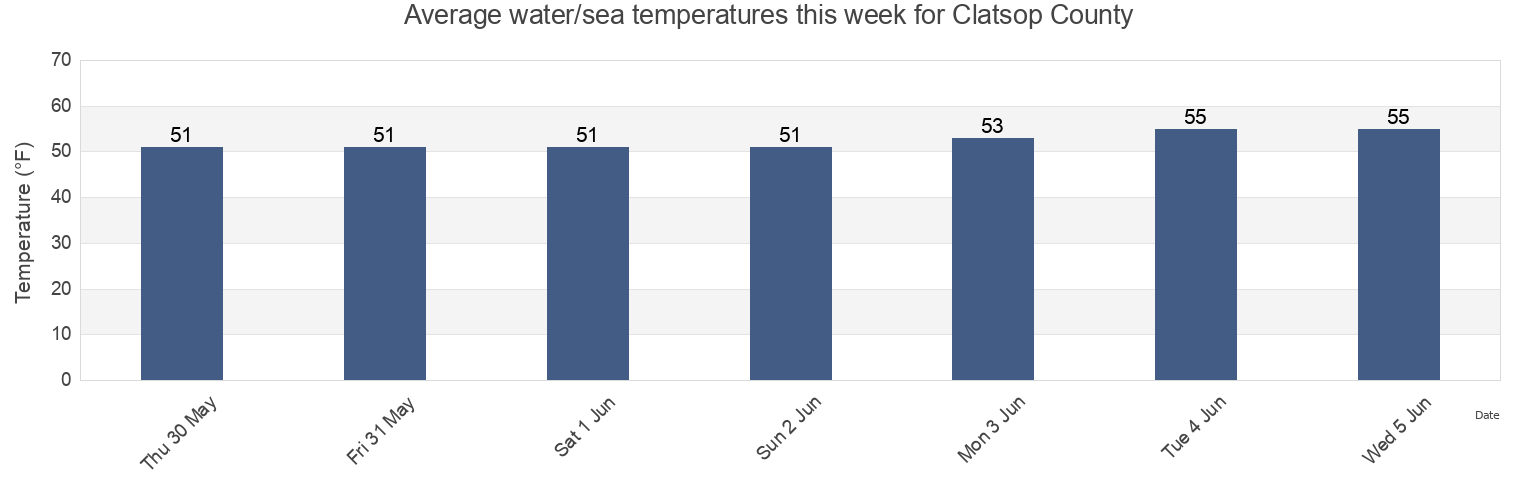
Clatsop County water temperature
Clatsop County water temperature for today, tomorrow and this week
More tide and marine information for Clatsop County
Today's tides
Weekly tides
Weather
Fishing tides
Regions and cities in Clatsop County, Oregon, United States
Arcadia Beach
Gearhart
Sand Island SSE of
Arcadia Beach
Hammond
Sand Island Tower 1nm SE of (midchannel)
Arch Cape
Hammond northeast of ship channel
Seaside
Astoria
Hammond Oreg
Seaside Reef
Astoria (port docks)
Hug Point
Settlers Point
Astoria (Tongue Point)
Hungry Harbor
Settlers Point Oreg.
Show more locations
Astoria (Youngs Bay)
Hungry Harbor Wash.
Short Sand Beach
Cannon Beach
Indian Beach
Short Sands
Cannon Beach/TolovanaBeach
Indian Beach/Ecola State Park
Sunset Beach Gearhart
Cathcart Landing
McGowan SSW of
Sunset Beach Tillamook
Chapman Beach
New Jetty/South Jetty
Tongue Point northwest of
Chinook Point WSW of
Oswald State Park/Short Sands
Warrenton
Clatsop Spit NNE of
Point Adams NNE OF
Warrenton (Skipanon River)
Cove Beach
Point Adams Oreg.
Warrenton Skipanon River Oreg.
Crescent Beach
Point Ellice east of
Youngs Bay Bridge
Tide charts near Clatsop County
Cathcart Landing
Gearhart
Seaside Reef
Settlers Point Oreg.
Settlers Point
Seaside
Astoria (Youngs Bay)
Sunset Beach Tillamook
Sunset Beach Gearhart
Astoria