Pinellas County tide charts for today, tomorrow and this week

Pinellas County, Florida, United States tide chart

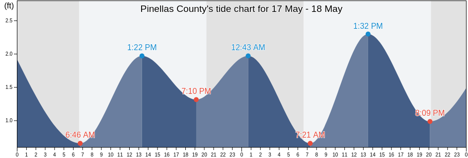
Saturday 27 April 2024, 3:10PM EDT (GMT -0400). The tide is currently rising in Pinellas County. As you can see on the tide chart, the highest tide of 2.95ft will be at 5:17pm and the lowest tide of -0.33ft was at 1:10am. Click here to see Pinellas County tide chart for the week.

Next high tide

Next high tide is at
5:17pm

Next low tide

Next low tide is at
2:04am

Tide times for Pinellas County

Tide table for Pinellas County this week
Day Tide times for Pinellas County Sunrise and sunset
1st Tide 2nd Tide 3rd Tide 4th Tide
Sat 271:10am
-0.33 ft
8:32am
1.64 ft
10:52am
1.64 ft
5:17pm
2.95 ft
6:54am 8:03pm
Sun 282:04am
-0.33 ft
6:01pm
2.95 ft
6:53am 8:04pm
Mon 293:06am
-0.33 ft
6:55pm
2.95 ft
6:52am 8:04pm
Tue 304:15am
-0.33 ft
8:05pm
2.95 ft
6:51am 8:05pm
Wed 15:22am
-0.33 ft
9:34pm
2.62 ft
6:50am 8:05pm
Thu 26:21am
-0.33 ft
1:44pm
1.97 ft
5:53pm
1.64 ft
11:13pm
2.62 ft
6:49am 8:06pm
Fri 37:11am
0 ft
1:51pm
1.97 ft
7:17pm
1.31 ft
6:49am 8:07pm

Best fishing times for Pinellas County today Today is an average fishing day

Major fishing times

From 10:27am to 12:27pm

Opposing lunar transit (moon down)

From 10:58pm to 12:58am

Lunar Transit (moon up)

Minor fishing times

From 8:41am to 9:41am

Moonset

From 11:28pm to 12:28am

Moonrise

Click here to see Pinellas County fishing times for the week.

Current weather in Pinellas County

Partly cloudy

Weather

Cloud cover 24%
Temperature

Temperature

81°F
Min 70°F/Max 82°F
Wind

Wind

17 mph
Wind gust 26 mph
Humidity

Humidity

47%
Dew point 59°F

Click here to see Pinellas County weather for the week.

Today's weather in Pinellas County

The sun rose at 6:54am and the sunset will be at 8:03pm. There will be 13 hours and 09 minutes of sun and the average temperature is 78°F. At the moment water temperature is 70°F and the average water temperature is 70°F.

Weather forecast for Pinellas County today
0 h 3 h 6 h 9 h 12 h 15 h 18 h 21 h 24 h
Partly cloudyPartly cloudyPartly cloudyPartly cloudyPartly cloudyPartly cloudyPartly cloudyPartly cloudyPartly cloudy
73°F74°F82°F74°F79°F81°F82°F75°F72°F

Click here to see Pinellas County weather for the week.

More tide and marine information for Pinellas County

Regions and cities in Pinellas County, Florida, United States

0.5 mile southeast ofGreenhillRedington Rocks
1.9 miles SE ofGulfportRedington Shores
2.6 miles south ofHarbor BluffsRidgecrest
3 miles southeast ofHolmes Beach PierRiviera Bay
Anclote (Anclote River)Honeymoon IslandRoss Island 1 mile east of marker 4
Anclote Anclote RiverHoran Head, South BaySafety Harbor
Anclote Key (Southern End)Indian Rocks BeachSafety Harbor (Old Tampa Bay)
Anclote Key Southern EndIndian Rocks Beach (inside)Safety Harbor Old Tampa Bay
Bay Aristocrat VillageIndian ShoresSaint George
Bay Aristocrat Village (Old Tampa Bay)Johns PassSaint Joseph Sound
Bay Aristocrat Village Old Tampa BayJohns Pass Bridge 0.3nm north ofSaint Pete Beach
Bay PinesJohns Pass Bridge north spanSaint Petersburg
Bellair BeachJohns Pass EntranceSakonnet River Break
BelleairKenneth CitySand Key Jetty
Belleair BeachKlosterman PointSeaside Point
Belleair BluffsLargoSeminole
Blind Pass (north end)Largo InletSmacks Bayou
Boca Ciega BayLealmanSnell Isle 1.8 miles east of
Bridge 0.8 mi. south of Maximo Pt.Lewis Island 0.9 mile east ofSouth Beach Pavilion
Bunces Pass (West of Bayway bridge)Lido BeachSouth Highpoint
Caladesi IslandLong BayouSouth Pasadena
Camp Key 1.9 miles northwest ofLong KeySouthwest Channel (S of Egmont Key)
Cats Point (bridge west of)Long Key (0.5mi N. Of Corey Causeway)St Pete Beach
Clam BayouLong Key 0 5mi N of Corey CausewaySt Petersburg
ClearwaterMadeira BeachSt. Pete Beach
Clearwater BeachMadeira Beach CausewaySt. Petersburg
Clearwater Pass 0.2 mi. NE of Sand KeyMaderia BeachSt. Petersburg Beach Causeway
Coffeepot BayouMobbly BayouSunset Beach
Courtney Campbell ParkwayMullet Key Channel (skyway)Sunshine Skyway Bridge
Cross BayouMullet Key Channel entranceSutherland Bayou
Cut E Channel marker 2EMullet Key Channel marker 24Tampa Bay
De Soto PointNorth Anclote KeyTampa Bay (Sunshine Skyway Bridge)
DunedinNorth Redington BeachTampa Bay Entrance (Egmont Channel)
Dunedin (St. Joseph Sound)Old Port TampaTarpon Springs
East Beach LighthouseOld Tampa Bay Entrance (Port Tampa)Tarpon Springs (Anclote River)
East LakeOldsmarTarpon Springs Anclote River
Egmont Channel (3 mi. W of Egmont Key Lt.)Palm HarborThe Narrows (Indian Rocks Beach Bridge)
Egmont Channel marker 10Pass-a-Grille BeachTierra Verde
Egmont Key (Egmont Channel)Pass-a-Grille Beach Boca Ciega BayTreasure Island
Egmont Key Egmont ChannelPass-a-Grille ChannelUpham Beach
Feather SoundPass-A-Grille JettyW Howard Frankland Bridge
Fort DeSoto Dog BeachPassage Key Inlet (off Bean Pt.)Weedon Hammock
GandyPine Key (Pinellas Bayway bridge)Weedon I. powerplant channel marker 10
Gandy Bridge (Old Tampa Bay)Pinellas ParkWeedon Island
Gandy Bridge east channelPoint PinellasWest and East Lealman
Gandy Bridge Old Tampa BayPort Manatee Channel entrance
Gandy Bridge west channelRedington Beach