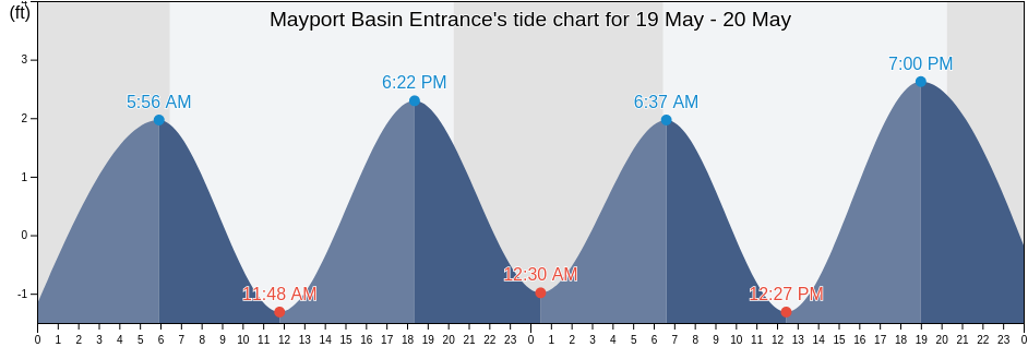
Sunday 28 April 2024, 3:04AM EDT (GMT -0400). The tide is currently falling in Mayport Basin Entrance. As you can see on the tide chart, the highest tide of 1.97ft will be at 12:11pm and the lowest tide of -2.3ft will be at 5:53pm. Click here to see Mayport Basin Entrance tide chart for the week.
Next high tide is at
12:11pm
Next low tide is at
6:13am
Tide times for Mayport Basin Entrance
| Day | Tide times for Mayport Basin Entrance |
|
||||
|---|---|---|---|---|---|---|
| 1st Tide | 2nd Tide | 3rd Tide | 4th Tide | |||
| Sun 28 | 6:13am ▼ -1.64 ft | 12:11pm ▲ 1.97 ft | 5:53pm ▼ -2.3 ft | ▲ 6:44am | ▼ 8:02pm | |
| Mon 29 | 12:48am ▲ 3.28 ft | 7:12am ▼ -1.64 ft | 1:04pm ▲ 1.97 ft | 6:50pm ▼ -2.3 ft |
▲ 6:43am | ▼ 8:03pm |
| Tue 30 | 1:42am ▲ 2.95 ft | 8:14am ▼ -1.97 ft | 2:05pm ▲ 1.64 ft | 7:57pm ▼ -1.97 ft |
▲ 6:42am | ▼ 8:03pm |
| Wed 1 | 2:41am ▲ 2.95 ft | 9:12am ▼ -1.97 ft | 3:13pm ▲ 1.97 ft | 9:08pm ▼ -1.97 ft |
▲ 6:41am | ▼ 8:04pm |
| Thu 2 | 3:45am ▲ 2.95 ft | 10:05am ▼ -2.3 ft | 4:19pm ▲ 2.3 ft | 10:14pm ▼ -1.97 ft |
▲ 6:41am | ▼ 8:05pm |
| Fri 3 | 4:46am ▲ 2.62 ft | 10:55am ▼ -2.3 ft | 5:20pm ▲ 2.62 ft | 11:17pm ▼ -1.97 ft |
▲ 6:40am | ▼ 8:05pm |
| Sat 4 | 5:46am ▲ 2.62 ft | 11:46am ▼ -2.62 ft | 6:16pm ▲ 2.95 ft | ▲ 6:39am | ▼ 8:06pm | |
Best fishing times for Mayport Basin Entrance today Today is an average fishing day
Major fishing times
Minor fishing times
Click here to see Mayport Basin Entrance fishing times for the week.
Current weather in Mayport Basin Entrance
Weather
Cloud cover 47%
Temperature
73°F
Min 69°F/Max 74°F
Wind
15 mph
Wind gust 22 mph
Humidity
67%
Dew point 59°F
Click here to see Mayport Basin Entrance weather for the week.
Today's weather in Mayport Basin Entrance
The sun will rise at 6:44am and the sunset will be at 8:02pm. There will be 13 hours and 18 minutes of sun and the average temperature is 72°F. At the moment water temperature is 68°F and the average water temperature is 68°F.
Click here to see Mayport Basin Entrance weather for the week.
More tide and marine information for Mayport Basin Entrance
Tide charts near Mayport Basin Entrance
- Degaussing Structure
- St. Johns Bar Cut 0.7 n.mi. east of jetties
- St. Johns River at Navy degaussing structure
- Mayport Naval Station Degausing Structure
- St. Johns River Ent. (between jetties)
- St. Johns River Entrance
- Mayport Naval Station Water Treatment Dock
- Mayport Naval Sta. (St Johns River)
- Mayport Naval Sta. St Johns River
- Bar Cut 0.6 n.mi. ENE of St. Johns Point