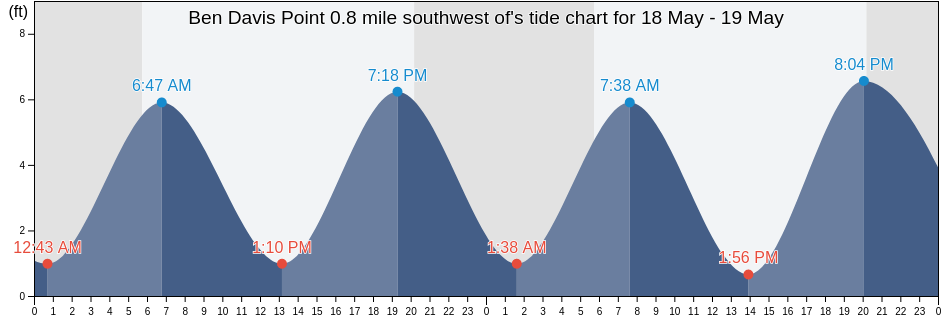
Saturday 27 April 2024, 2:30PM EDT (GMT -0400). The tide is currently falling in Ben Davis Point 0.8 mile southwest of. As you can see on the tide chart, the highest tide of 6.89ft was at 12:06am and the lowest tide of 0.66ft was at 7:21am. Click here to see Ben Davis Point 0.8 mile southwest of tide chart for the week.
Next high tide is at
12:43am
Next low tide is at
7:00pm
Tide times for Ben Davis Point 0.8 mile southwest of
| Day | Tide times for Ben Davis Point 0.8 mile southwest of |
|
||||
|---|---|---|---|---|---|---|
| 1st Tide | 2nd Tide | 3rd Tide | 4th Tide | |||
| Sat 27 | 12:06am ▲ 6.89 ft | 7:21am ▼ 0.66 ft | 12:45pm ▲ 5.58 ft | 7:00pm ▼ 0.98 ft |
▲ 6:07am | ▼ 7:51pm |
| Sun 28 | 12:43am ▲ 6.89 ft | 8:06am ▼ 0.98 ft | 1:28pm ▲ 5.58 ft | 7:43pm ▼ 0.98 ft |
▲ 6:06am | ▼ 7:52pm |
| Mon 29 | 1:29am ▲ 6.89 ft | 8:55am ▼ 0.98 ft | 2:20pm ▲ 5.58 ft | 8:37pm ▼ 0.98 ft |
▲ 6:04am | ▼ 7:53pm |
| Tue 30 | 2:25am ▲ 6.56 ft | 9:50am ▼ 0.98 ft | 3:22pm ▲ 5.58 ft | 9:43pm ▼ 0.98 ft |
▲ 6:03am | ▼ 7:54pm |
| Wed 1 | 3:31am ▲ 6.56 ft | 10:48am ▼ 0.98 ft | 4:29pm ▲ 5.58 ft | 10:54pm ▼ 0.98 ft |
▲ 6:02am | ▼ 7:55pm |
| Thu 2 | 4:43am ▲ 6.56 ft | 11:47am ▼ 0.66 ft | 5:34pm ▲ 5.91 ft | ▲ 6:01am | ▼ 7:56pm | |
| Fri 3 | 12:03am ▼ 0.98 ft | 5:52am ▲ 6.56 ft | 12:44pm ▼ 0.33 ft | 6:35pm ▲ 6.56 ft |
▲ 6:00am | ▼ 7:57pm |
Best fishing times for Ben Davis Point 0.8 mile southwest of today Today is an average fishing day
Major fishing times
Minor fishing times
Click here to see Ben Davis Point 0.8 mile southwest of fishing times for the week.
Current weather in Ben Davis Point 0.8 mile southwest of
Weather
Temperature
Wind
Humidity
Click here to see Ben Davis Point 0.8 mile southwest of weather for the week.
Today's weather in Ben Davis Point 0.8 mile southwest of
The sun rose at 6:07am and the sunset will be at 7:51pm. There will be 13 hours and 44 minutes of sun and the average temperature is 52°F. At the moment water temperature is 50°F and the average water temperature is 50°F.
Click here to see Ben Davis Point 0.8 mile southwest of weather for the week.
More tide and marine information for Ben Davis Point 0.8 mile southwest of
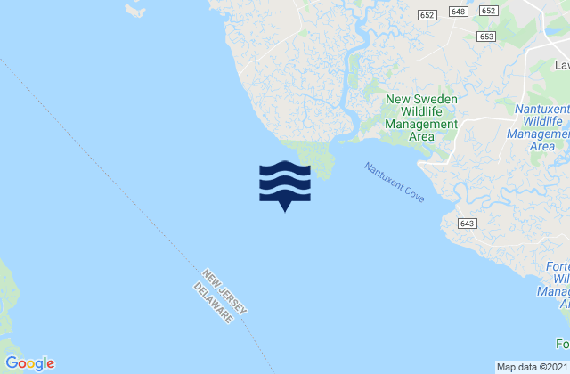
Tide charts near Ben Davis Point 0.8 mile southwest of
- Back Creek Entrance (Nantuxent Cove)
- Back Creek Entrance Nantuxent Cove
- Ben Davis Pt. Shoal southwest of
- Ben Davis Point 3.2 n.mi. SW of
- Cedar Creek Entrance Nantuxent Cove
- Cedar Creek Entrance (Nantuxent Cove)
- Money Island (Nantuxent Creek Entrance)
- Money Island Nantuxent Creek Entrance
- Ship John Shoal
- Cohansey River 0.5 mile above entrance